Quick Stops: fast, fascinating, fun, funky!


IMG_1111
Cold and lonely highway

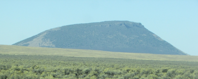
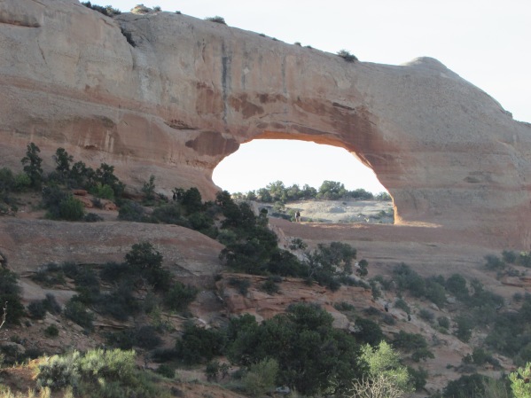
We decided to do Quick Stops to showcase places that merit a nod, shout out, or round of applause but to which we can’t devote an entire post. As we’ve said before, we will drive a long way out of the way or completely change up our itinerary to go see something that piques our interest. (We must be channeling Clark Griswold. Thankfully, neither of us has an Aunt Edna!) Some of the places we plan to feature in the Quick Stops posts will be fascinating, some will be fun, and some will be funky! Additionally, some locations will be on the beaten path, some will be off of it, and some may just be a photo we like, such as the desolate road above. The locations will be posted at random, and there will be no particular order or itinerary. We can’t wait to share them with you!

Just get in the car and we’ll be on our way…

First Stop: Monument Rocks (Kansas)

Where in the world is it?

IMG_1704

Monument Rocks is about 28 miles south and east of Oakley, Kansas off of US Highway 83. The landmark is on private land, and some of the roads to get there are unnamed, graded dirt ranch roads. These roads can be very bumpy and muddy, but under normal conditions it is well worth the trip to see the rocks. Take a look…


IMG_1730

IMG_1721

IMG_1729

Truly out in the middle of nowhere, these fascinating rocks are the remains of an ancient sea bed.

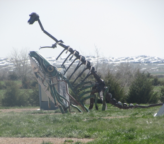
Second stop: Carhenge (Nebraska)

Where in the world is it?

Carhenge is located about four miles north of Alliance, Nebraska. This funky tourist stop is on private property, but thanks to the property owners there is no entrance fee. The sculpture can be viewed from outside the fence that surrounds it. Check it out…

IMG_1184

IMG_1187
Other sculptures at Carhenge

It’s a fact, Jack!

Below is the sign for the Annie Oakley Motel in Oakley, Kansas. Annie Oakley was not from Kansas (she was from Ohio), but she was a performer in Buffalo Bill Cody’s Wild West Show. Buffalo Bill Cody once called Oakley, Kansas home. And now you know…

img_1708-e1541977411489.jpg

That does it for this week. Thank you for joining us! Come back next week for another exciting post. You never know where we are going to take you! If you liked our first Quick Stops post, leave us a message and let us know we should keep doing them. If you didn’t like it, tell us that, too. Until the next trip…

Travel safe, travel smart, and we will see you down the road!

Mike and Kellye 

IMG_2120

As always, we strive to be as accurate with our information as possible. If we made a mistake, it was unintentional. (Hey, we’re only human!) We aren’t paid for our recommendations, and we only recommend our own tried and true vendors and venues. Our suggestions are for places that we’ve heard good things about but haven’t visited personally, and our opinions are our own.

©2018


Craters of the Moon National Monument


img_0752.jpg
Lava field. The white dome in this picture is called a kipuka.
  • IMG_0732Website: Craters of the Moon
  • Visitor center hours vary by season
  • Campground in the park
  • Backcountry camping permitted in the preserve
  • Scenic drive
  • Hiking
  • Picnic areas
  • Caving
  • International Dark Sky Park
  • When to go: anytime.
IMG_0727
Lava flow

Getting There

IMG_0675

Idaho Falls, Idaho, which is 130 miles from Craters of the Moon, has a regional airport that is served by a few national carriers. We are going to start our trip from there, so get your camera ready and let’s hit the road!

Note: Salt Lake City, Utah has the closest major airport and is 300 miles from Craters of the Moon.

From Idaho Falls take Highway 20 west toward Arco, Idaho.

Bonus stop: EBR-1 National Historic Landmark. For those wanting to satisfy their inner geek, this stop is for you. EBR-1 was the first nuclear reactor to generate electricity, and it is located at Idaho National Laboratory (INL). Unfortunately, the museum is only open only during the summer.

IMG_0701Travel tip: West of INL on the South side of Highway 20, there is a rest area (with nice restrooms) that has some outside displays with great information about the region. We recommend spending a few minutes there learning about Nuclear Reactors, the Eastern Snake River Plain, the Great Rift, the Lost Rivers, and other interesting topics.

IMG_0709
Just one example of the beauty of Idaho

Below is one of several buttes (volcanic perhaps?) along Highway 20 between Idaho Falls and Arco. This region has many lava flows, cones, rifts, and other volcanic features, most of which are contained in the Craters of the Moon National Monument and Preserve. The combined lava flows of the monument and preserve cover over 600 square miles. That’s a lotta lava! Check it out on Google Earth sometime.

IMG_0695

Continue west on Highway 20 to the town of Arco, Idaho.

Bonus stop: Arco, Idaho.

IMG_0771

Stop in Arco to see Number Hill, and we recommend stopping for lunch at Pickle’s Place, which has good food in a retro diner atmosphere. We ate at the counter with a local man who told us the story of the Apollo astronauts coming to Arco in the 1960s to train at Craters of the Moon National Monument. Hearing his story was one of the highlights our trip.

From Arco take US Highway 26/93 west 19 miles to Craters of the Moon National Monument and Preserve Visitor Center. Drive time between Idaho Falls and Craters of the Moon: 2 hours.

Travel tip: as with many remote sites, GPS systems may not be reliable for directions to this park. Refer to your road atlas if in doubt.

Destination: Craters of the Moon National Monument and Preserve

The first stop is the visitors center where films, displays, and exhibits explain the characteristics of the park. Learn to identify the many different types of lava, and find out if the volcanoes are still active. The pictures below show some of the features of the park.

IMG_0760
Spatter cones
IMG_0750
Inferno Cone Trail
IMG_0728
Lava flow and cinder cones
IMG_0764
Spatter Cone
IMG_0761
We love the contrasting landscapes of this shot! (This type of lava is called a’a.)

Thank you for joining us on our visit to Craters of the Moon. We post our journeys simply because we love sharing them with you. Our hope and mission is for you to be inspired by our photos and guided by our experiences in order to seek your own adventures in the wonderful national parks and beautiful cities of our great country. For those who can’t “just get in the car”, we love that we can provide you with virtual travel experiences. Please leave us a message below and tell us about your own travels. We would love to hear from you. Until the next trip…

Travel safe, travel smart, and we will see you down the road!

Mike and Kellye 

IMG_2120

As always, we strive to be as accurate with our information as possible. If we made a mistake, it was unintentional. (Hey, we’re only human!) We aren’t paid for our recommendations, and we only recommend our own tried and true vendors and venues. Our suggestions are for places that we’ve heard good things about but haven’t visited personally, and our opinions are our own.

©2018


Death Valley National Park

IMG_2653

  • Website: Death Valley National Park
  • Hotels/resorts and campgrounds in the park
  • Restaurants and concessions in the park
  • Scenic drives
  • Historic sites
  • Hiking
  • Backpacking
  • Backcountry camping
  • When to go? Winter, early spring, late fall are the best times to visit. Visitors should be extremely cautious in the summer months when temperatures rise dramatically.
IMG_2580
Devil’s Golf Course – these “rocks” are actually salt crystals. The Panamint Mountains made a nice backdrop for this shot.

Getting There

Our trip is going to start in Las Vegas, Nevada, which has a major airport and is only 123 miles from Death Valley. Ice down a cooler full of water, grab your favorite road snacks, and let’s go to Death Valley!

From Las Vegas, take I-15 south to Highway 160 west to Pahrump, Nevada.

Travel tip: make a restroom stop and top off your gas tank in Pahrump.

From Pahrump, continue northwest on Highway 160 to Bell Vista Avenue. Take Bell Vista (which changes to Bell Vista Road) west across the California state line to Death Valley Junction and Highway 190. Continue into the park on Highway 190. Drive time between Las Vegas and Death Valley: 2 hours.

Travel tip: Look for wild burros and horses along Highway 190.

Destination: Death Valley National Park

IMG_2601Arguably, Death Valley holds the record for the hottest temperature ever recorded on earth – 134º F in July of 1913. Badwater Basin is the lowest point in North America, sitting at 282 feet below sea level. With an average of 1.5 inches of rain per year, Death Valley also holds the honor of being the driest place in North America. We are used to hot, dry weather where we live, but the 111º F (before noon) temperature when we visited Death Valley felt like a different type of oppressive heat that seemed heavier to us for some reason. With that said, we caution you to be conscious of the weather and prepare for harsh conditions when visiting this park, especially in the late spring, summer, and early fall. Also, make sure your car is in tip-top condition before starting a road trip through Death Valley.

IMG_2602
This is a spring in the salt flats at Badwater Basin, but the water is too salty to drink.

Death Valley is hot, dry, and its spring water is too salty for humans or animals to drink. So why would anyone want to go there? Well, see below…

IMG_2610
Breathtaking Beauty
IMG_2611
Vibrant Colors at Artist’s Palette
IMG_2626
Magnificent Mountain Vistas

When thinking of a desert, one usually thinks of sand dunes and scrubby cactus. At least that is what we envision when we imagine desert scenery. Death Valley is different from other deserts because of its diversity. The park features 11,000 foot mountains, wildflower super blooms after rare rains, as well as sand dunes. Badlands, salt flats, and dry lake beds where rocks race across the parched ground on their own, can also be seen here. With so much to offer, it’s easy to see the many facets of this unique landscape. And speaking of lake beds, all of Death Valley was once a lake. A trip here is definitely worth the time, and it’s not just about the scenery. This park also features oases, historic ghost towns, abandoned mines, and even a castle!

IMG_2629
Badlands of Zabriskie Point
IMG_2606
Salt Flats of Badwater Basin
IMG_2632
Multi-faceted Beauty

Did you know that borax was once mined in Death Valley? The mine was called Harmony Borax Works, and they hauled the borax 165 miles to Mojave, California, using huge wagons pulled by teams of twenty mules. One of the wagons can still be seen at the Furnace Creek Visitor Center. The trip from Death Valley to Mojave took ten days and had to have been grueling. Today at Death Valley, there is a park road through scenic Twenty Mule Team Canyon. While the wagons probably didn’t travel this exact area, it is a wonder how they managed to get their animals and wagons through the rugged terrain of what is now Death Valley National Park.

IMG_2639
In Twenty Mule Team Canyon
IMG_2636
View of the terrain and park road through Twenty Mule Team Canyon

Thank you for joining us on our trip to Death Valley National Park! We hope that we have given you some insight and inspiration for planning your own trip to see this wondrous place. That is our goal in sharing our information, after all. We will leave you with one last look at beautiful, otherworldly Zabriskie Point.

IMG_2631

Until the next trip…

Travel safe, travel smart, and we will see you down the road.

Mike and Kellye

IMG_2120

As always, we strive to be as accurate with our information as possible. If we made a mistake, it was unintentional. (Hey, we’re only human!) We aren’t paid for our recommendations, and we only recommend our own tried and true vendors and venues. Our suggestions are for places that we’ve heard good things about but haven’t visited personally, and our opinions are our own.

©2018


Canyonlands National Park

IMG_2380

  • Website: Canyonlands National Park.
  • Camping available in the park. Backcountry camping available with permit.
  • Hotels and restaurants available in Moab, Utah.
  • Hiking, biking, climbing, river activities and backpacking are all popular activities in this park.
  • When to go? Anytime.

Although it is practically next door to Arches National Park, Canyonlands is an entirely different experience! The park’s unique terrain was shaped mostly by the Green and Colorado rivers which converge in the park. The Colorado River then flows to Lake Powell and onward through the Grand Canyon to Lake Meade and on farther until finally emptying into the Gulf of California. Ah, the power of water… Let’s go see how it helped to create beautiful Canyonlands National Park. By the way, this trip starts in Moab. Why? Because if you’re already in Moab, then a visit to Canyonlands has to be on your itinerary.

IMG_2387

Getting There

From Moab, take Highway 191 North to Highway 313, then south on 313 to Canyonlands National Park. Drive time between Moab and Canyonlands: 30 minutes.

Bonus stop: Dead Horse Point State Park. Beautiful state park that abuts Canyonlands National Park. Hiking, biking, camping, coffee shop, and store. Yurt rentals are also available. Don’t miss Dead Horse Point overlook for spectacular views, especially the gooseneck bend in the Colorado River.

The Colorado River as seen from the viewpoint at Dead Horse Point State Park

Destination: Canyonlands National Park

IMG_2391

The park is divided into four sections: Island in the Sky, Horseshoe Canyon, The Maze, and The Needles. Backcountry backpacking may be needed to reach some areas of the park. We got to see the Island in the Sky area and The Needles Overlook. Hopefully the pictures below will give you a little glimpse into the true beauty of the park.

IMG_2396
Fins, spires, hoodoos, and mesas as seen from Island in the Sky

IMG_2325To get from Island in the Sky to The Needles Overlook, go back to Moab, then take Highway 191 south to Needles Overlook Road. Nice little hike from the parking lot to the overlooks. Excellent views and photo ops. Great place for a picnic. Drive time between Island in the Sky to The Needles Overlook: 1.5 hours.

Bonus stop: Wilson Arch. Beautiful arch 30 minutes south of Moab on Highway 191. Hike the (steep) hill to the arch, or just pull over for a few photos.

IMG_2322
Wilson Arch
IMG_2356
View from The Needles Overlook

We hope that our overview of Canyonlands National Park has given you the inspiration to start planning your own trip. Click the website link at the top of the page for information about the park. While you’re in the area, here are some other parks that are worthy of a side trip from Moab:

  • IMG_2327Natural Bridges National Monument – 2 hours;
  • Hovenweep National Monument – 2 hours;
  • Canyons of the Ancients National Monument – 2 hours;
  • Four Corners – 2.5 hours
  • Monument Valley – 3 hours.

Thank you for riding along with us! Until the next trip…

Travel safe, travel smart, and we will see you down the road.

Mike and Kellye  

IMG_2120

As always, we strive to be as accurate with our information as possible. If we made a mistake, it was unintentional. (Hey, we’re only human!) We aren’t paid for our recommendations, and we only recommend our own tried and true vendors and venues. Our suggestions are for places that we’ve heard good things about but haven’t visited personally, and our opinions are our own.

©2018